Shimla received its first snowfall of the season on Sunday. The Meteorological Department said some areas of the city received up to six centimeters of snow, while most other areas received rain. Two nearby hill stations of Kufri and Narkanda received 12 cm and 16 cm of snow, respectively. Thousands of tourists reached Kufri to enjoy the snowfall.
There was snowfall in Jammu and Kashmir as well. However, the Meteorological Department has said that till January 18, the weather will be mainly dry over the entire region.

By that time the night temperature will further decrease. A fresh Western Disturbance is very likely to affect JK from January 19 to 25. There is a possibility of light to moderate rain or snowfall between January 23 and 24.
Kashmir is currently in the grip of ‘Chillai Kalan’, the harshest weather period of 40 days when the chances of snowfall are maximum and highest. and answer India At present, cold wave is in the grip and it is getting cold in the areas of Delhi, Haryana and Punjab.
While tourists are enjoying the weather and snowfall, experts agree that the onset and average amount of snowfall so far this season has been low. Why is this? News18 explains:
What the experts say:
Talking about snowfall in the Jammu and Kashmir region this season, IMD weather forecaster and meteorologist Mohammad Hussain Mir told News18 that climate variability is always present due to global wind patterns, which is why this season There could be a slight delay or early start of snow and rain. The winter season.
“In the last three years, we were witnessing the onset of snowfall from November. This time, it has come in December (which is usually its normal time) and the average snowfall has been below normal,” Mir said.

This, he said, was due to changes in global wind patterns, which caused climate change. “Wind patterns will not be uniform across the globe, leading to variability. subtropical westerly jetstreamThe average height (above ground level) is about 10-12 km. Its normal position is 28°N (Delhi region), but this year it was 30-34°N, which caused the delay as it is the main source of rain and snow.”
On the snowfall forecast in the region, Mir said, at present, the subtropical westerly jet stream was at exactly 28 degree north, which would result in an increase in snowfall from January 22 to January 24.
Uttarakhand has observed a similar pattern of delayed snow and below average rainfall. IMD department scientist Rohit Thapliyal explained to News18 that this was also due to the absence of any strong Western Disturbance. “Even those that came through north region like Jammu and Kashmir and Himachal, and this has resulted in drop in moisture from Arabian Sea,” he added.
Talking about the forecast, he said that a Western Disturbance is forming around January 18, which will cause light snowfall over the higher reaches of Uttarakhand like Uttarkashi, Chamoli etc. and fog towards the plains.
To understand this better, let us know what is Western Disturbance.
What is Western Disturbance?
A western disturbance is an extratropical storm that forms in the Mediterranean region and brings heavy winter rain to the northern Indian subcontinent, extending east to northern Bangladesh and southeastern Nepal.
Westerly winds are driving a non-monsoon rain pattern. The moisture in these storms usually originates from the Mediterranean, Caspian and Black Seas. An extratropical storm is a global phenomenon that carries moisture into the upper atmosphere, in contrast to a tropical storm, which carries moisture into the lower atmosphere.
When a storm system hits the Himalayas, the moisture is sometimes dumped as rain over the Indian subcontinent. During winter, Western Disturbances become more frequent and stronger.
Does it have a climate change link?
The India Meteorological Department said on Wednesday that 2022 was the warmest December in 122 years. Hindustan Times Told.
There was no cold wave, cold day or dense fog over northern and central India till 15 December. And the colder days started on 21 December.

IMD Director General M Mohapatra said this Hindustan Times This was mainly because no strong Western Disturbance affected the Northwest region which mainly causes drop in temperature in winters.
Due to this, the temperature remained above normal throughout the month. “Apart from this, rains were confined to Tamil Nadu and Kerala, with most parts of the country receiving deficient rains, leading to rise in day temperatures,” he added.
According to experts, the high temperature in a La Nina year was unusual, the report said. “The northern regions were missing due to weak Western Disturbance activity. But climate change certainly has a role to play in raising average temperatures. We have now started seeing record breaking temperatures even in La Nina years,” said OP Sreejith, Head, Climate Monitoring and Prediction Group, IMD, Pune Hindustan Times,
M Rajeevan, climate scientist and former secretary, Ministry of Earth Sciences, was quoted in the report as saying that despite it being a La Nina year, Europe was experiencing a heat wave, and had recorded unusually high temperatures .
“Our December data shows the same. Global warming has weakened the effect of La Nina. We need to analyze what caused the increase in temperature in December but the overall record can certainly be linked to climate change.”
What are La Nina and El Nino?
According to National Geographic, La Nina is a climate pattern that describes the cooling of surface-ocean waters along the tropical west coast of South America. La Nina is considered the polar opposite of El Niño, which is characterized by unusually warm ocean temperatures in the equatorial region of the Pacific Ocean.

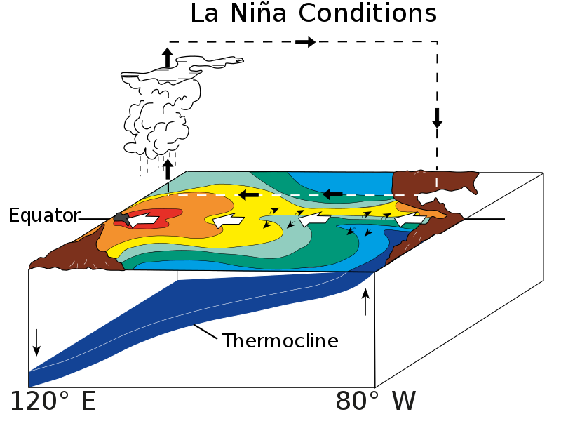
La Niña and El Niño are the “cool” (La Niña) and “warm” (El Niño) phases of the El Niño–Southern Oscillation (ENSO), respectively. ENSO is a group of weather and ocean-related phenomena and is characterized by changes in atmospheric pressure as well as abnormally warm or cold sea surface temperatures.
El Niño events are sometimes followed by La Niña events, which occur at irregular intervals of about two to seven years. The local effects of La Niña (“the little girl” in Spanish) on weather are generally opposite to those associated with El Niño (“the little boy” in Spanish). As a result, La Niña is also known as Anti-El Niño and El Viejo (the old man in Spanish).
It was a La Nina year, so how does it affect India?
World The Meteorological Organization previously predicted in 2022 that the first “triple dip” of the century, La Niña, would occur in three consecutive Northern Hemisphere winters. Meteorological stations around the world have confirmed that we are currently in one.
Triple dip La Nina has been observed only three times since 1950.
La Nina is characterized by lower than average air pressure over the western Pacific Ocean. These low pressure areas help in increasing the rainfall. Rainfall associated with the summer monsoon is above normal in Southeast Asia, especially in northwest India and Bangladesh. This benefits the Indian economy in general, as agriculture and industry depend on the monsoon, reports National Geographic.
However, despite the ‘cooling’ effect of La Nina, India experienced a warm December, which experts termed as worrying. And according to a new study, as reported by The Hindu, climate change will have a significant impact on El Nino-La Nina weather patterns by 2030, a decade earlier than previously predicted and separating the two regimes. That was four decades before the unsuggested time. , This is expected to cause additional global climate disruption.
read all latest explainer Here