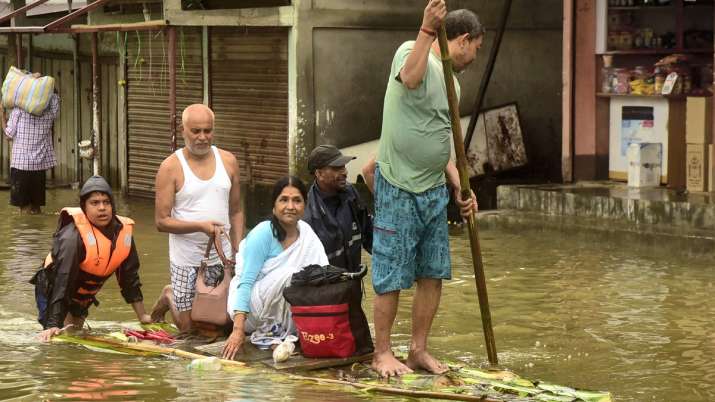
Flood affected people use banana raft to move to a safe place in Assam’s Bajli district.
Indian Institute of Technology, Guwahati will assist the Assam government in surveying flood-affected areas using drones developed by its startup to aid in relief and rescue operations. According to officials, the state government has approached the institute to specialize in survey of flood-affected areas using drones to assess the situation in villages where road connectivity has been disrupted due to heavy inflow of water. .
The flood situation in Assam remained extremely grim on Sunday with several new areas under the influence of floods in several districts of the state and incessant rain overnight in Guwahati inundating many areas. Incessant rains since the past one week have thrown normal life out of gear in some parts of Assam. Landslides were also reported from half a dozen places in the city including Kamakhya, Kharghuli, Hengrabari, Silpukhuri and Chandmari Colony.
Knee-feeling water and partially submerged vehicles were seen on submerged roads at several major intersections in the capital. At some places the water level even crossed the waist. The approach road of Guwahati railway station has also been submerged. “The government has contacted us and we will start work at the earliest. We will use drones to survey the affected areas. Also, to help the government develop an action plan for better preparedness before the monsoon. This exercise is important for us. Considering the weather, the region is prone to floods and landslides due to its geographical location,” said Parameshwara Iyer, Dean, IIT Guwahati.
Read also | IIT researchers develop new technology for charging electric vehicles that costs half of existing vehicles
“Drones will be used to conduct aerial survey of areas which have been severely affected and some villages where road connectivity is disrupted due to heavy water flow. This exercise will be helpful in identifying areas where people may be stranded. There is a need for immediate evacuation and there is a need to provide relief material.” Drones developed by IIT Guwahati in its startup venture, Drone Tech Lab, have previously been used for rapid data collection in several projects on land surveying, river mapping, agriculture, health care and disaster management.
“A major challenge in surveying flood affected areas with drones is the wind that comes along rivers during floods, so there is a need for drones equipped to counter the wind speed. These drones are used continuously in Majuli Island in Assam. This has been done in disaster management during floods and for prevention of dengue in Kolkata,” said Debjati Deka, Co-Founder of Drone Tech Lab.
Read also | Assam rain: Two children crushed in landslide due to heavy rains in the state
“Earlier, we have catered to various markets covering several Indian states including Karnataka, Jharkhand, West Bengal, Assam and Meghalaya. Survey and mapping find applications in various domains that range from mining activities to the use of drones. The exact quantity of the mine can be estimated with absolute accuracy.”
According to the latest update by the Assam State Disaster Management Authority (ASDMA), the state was witnessing floods and landslides for the past six days, leaving behind a huge trail of destruction everywhere. In the last 24 hours, 32 districts comprising 118 revenue divisions and 4,291 villages have reported floods. Around 31 lakh people have been affected, and 1.56 lakh of them have taken shelter in 514 relief camps across the state.
Read also | Assam floods: 54 deaths so far, PM Modi assures help as rains continue in the state
Read also | six lakh people stranded; Army called in to help flood-hit parts of Bangladesh